


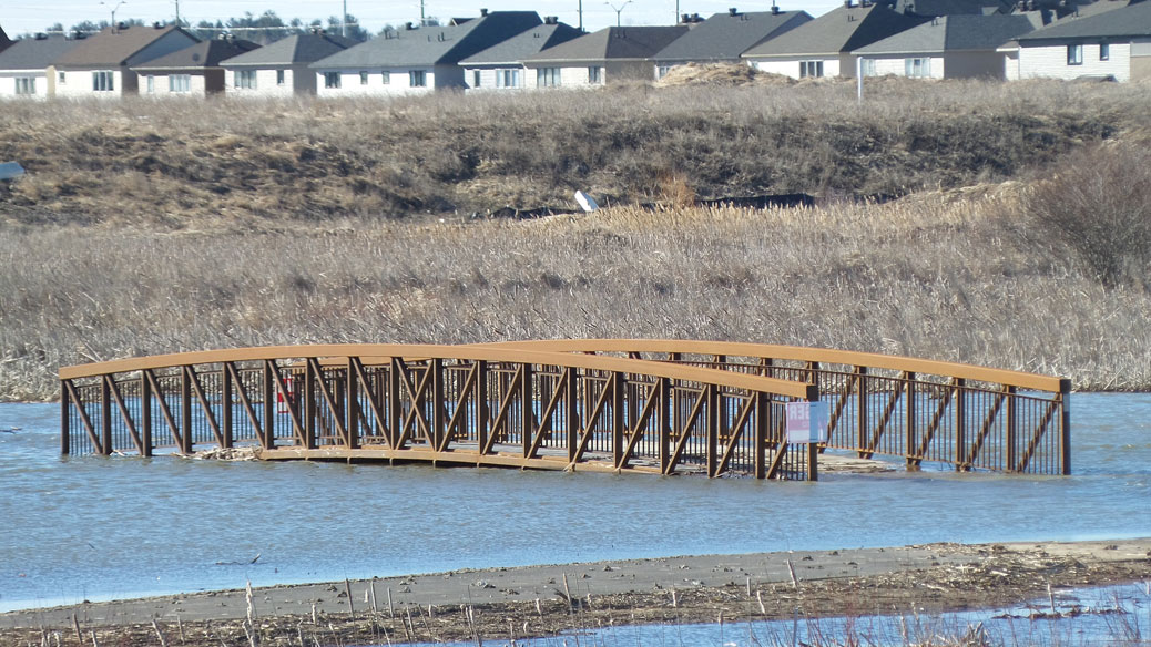
Carp River, April 8, 2017. The Arcadia neighbourhood is in the background.
(Thanks Karen for the headline pun.)
The mighty Carp River overflowed its banks during the first week of April, covering the adjacent floodplain and recreation paths with water. Officials say that’s completely normal.
The photos on this page were all taken on Saturday morning, April 8, after a few days of very heavy rain near the end of the spring melt. The bridge and paths that are covered with water are part of the new multi-use pathways installed last fall as part of the Carp River Restoration Plan (CRRP).
The CRRP is a massive multi-year engineering project along 5.2km of the Carp River from Hazeldean Road to north of Richardson Side Road. The existing Carp River will be altered to allow for development on land that for many years was considered a floodplain.
“This section of the Carp River corridor as show in the photograph has been constructed as designed and is functioning as expected,” wrote Don Herweyer, the City of Ottawa’s Manager of Development Review in an email to StittsvilleCentral.ca.
“The Carp River corridor experiences varying water levels during any given year depending on the severity of a storm event and/or spring snow melt. The corridor was designed to enhance its primary function as a water course and natural habitat, with a secondary function as a passive recreational area during the extensive low water level periods,” he wrote.
“The recreational system includes pathways and bridges. Parts of the pathway system have been designed and constructed at elevations below normal spring runoff water levels or storm events to ensure the pathways do not obstruct the water flow. For this reason it will be normal for some of the pathway system to be covered with water during peak run off periods such as is occurring now.”
In short, it’s perfectly normal that the bike paths will become canoe routes after severe storms, or during the spring melt.


***
We had a lot of precipitation in April, but it was all within the expected range, according to Gord Mountenay, Water Management Supervisor with the Mississippi Valley Conservation Authority (MVCA). The MVCA monitors water levels at several locations along the river.
“The only location in which there are historic flow records is at the Water Survey of Canada stream gauge near Kinburn. On April 8, 2017 the stream flow at the gauge site peaked at approximately 53 m3/s which at this location is would be considered less than a 1 in 5 year flood condition. The historic average peak flow in the spring at this location is 45 m3/s. The highest recorded peak flow at this location was 85 m3/s in 1972,” he told us by email.
“A water level gauge on the Carp River at Maple Grove Road is also monitored which recorded a peak water level of 93.34 meters on April 7, 2017. This corresponds to a maximum water level which would be expected to occur once every 2 years,” he wrote.
***
Beyond the inconvenience for people who use the path, some folks don’t think it’s safe to be building bike paths on a floodplain – even if the flooding is within the City’s expectations.
Sections of the pathway are engineered based on an expectation of a 10-50% chance of flooding in any year, where the river would overflow its banks and cover the pathways with anywhere from 30 to 100 centimetres of fast-moving water.
“The design would see those pathways flooded with a two-year storm,” he says. “It’s not in accordance with what one expect with responsible government to approve… I find this very disturbing,” said Erwin Dreessen of Ottawa’s Greenspace Alliance back in 2015.
When the engineering plans for the CRRP were being evaluated, a Ministry of Environment engineer had concerns about the potential for flooding: “Will the pedestrian pathway conform to the City’s risk management policy for stormwater conveyance infrastructure?” wrote Charles Goulet in a March 2014 email obtained via a freedom of information request. “…The mix of flooding waters and children is a dangerous one.” (More about that here.)
It’s probably a good idea to remind your kids to stay well away from the river when the water is high.
***
One more thing: A neighbour asked me the other day about where the Carp River pathway will cross the Queensway. The answer: it won’t.
Engineers couldn’t figure out how to go over or under the Queensway within an acceptable budget. So when the pathway is complete, you’ll have to travel up to Terry Fox or Huntmar to get over the Queensway. There also also longer-term plans for a pedestrian bridge over the Queensway, linking Canadian Tire Centre and the Arcadia neighbourhood.
https://twitter.com/live_2_bike/status/851538392953364481
Don't ya mean 'canoe and kayak' route… https://t.co/2MwWVima9A
— Don Wilcox (@donw_ottawa) April 10, 2017
Might get beaver tails after all… but it was a close thing. @glengower pic.twitter.com/FhiPcKJxqk
— Whelp?! (@bojnberry) April 9, 2017
Ok, maybe not. (Plus now my tires are so muddy they are stuck in the fenders. Good thing there’s so much water around) @glengower pic.twitter.com/9MvMoDBZzg
— Whelp?! (@bojnberry) April 9, 2017
https://twitter.com/SoupFox/status/851070931300605952
https://twitter.com/Stowecology/status/852888786790961152
There was a reason no pathways and bridges were constructed here long before the City took over.
Whose going to pay to have the pathways and bridges repaired and replaced if they wash away? It won’t be my tax dollar but it will be yours because I am moving to outside of the City’s clutch on my change pocket.