


All the strip malls and pavement make it hard to imagine today, but 50 years ago Hazeldean Road, all the way through Kanata South and into Stittsville, was lush green farmland.
The village of Hazeldean was situated at the crossroads of what’s now Hazeldean Road and Young Road. In the spring you would have seen rolling hills of green, cows and pigs alongside the road, children playing in the fields. There was a cheese factory, a brass band, a schoolhouse.
There are still a few hints of this history. There’s the gorgeous Sparks House that’s now “The Spa” on Castlefrank. There’s the Grierson Residence in front of the Goodlife on Hazeldean. Along Young Road you’ll find the old Masonic Hall and an old church, and there’s a hidden cemetery not far from the Tim Hortons on Edgewater – one of three cemeteries in the area.
Roger Young grew up in Hazeldean, and now calls Stittsville home. His family was one of the earlier 19th century settlers in the area and their name is still prominent: Young Road, Young’s Pond Park, John Young Elementary School.
“I was born in 1950 in Hazeldean and until the mid-60s it was almost as it had been at the turn of the century, if not longer,” he says. “One side of our farm is marked now by Terry Fox and the other by Young Road. I grew up there and knew all the elderly people and all the past residents of Hazeldean. I photographed the entire community before any of the housing was built. The original settlers came to Canada with the Talbot group in 1818 on the Brunswick and we would be the last family remaining.”
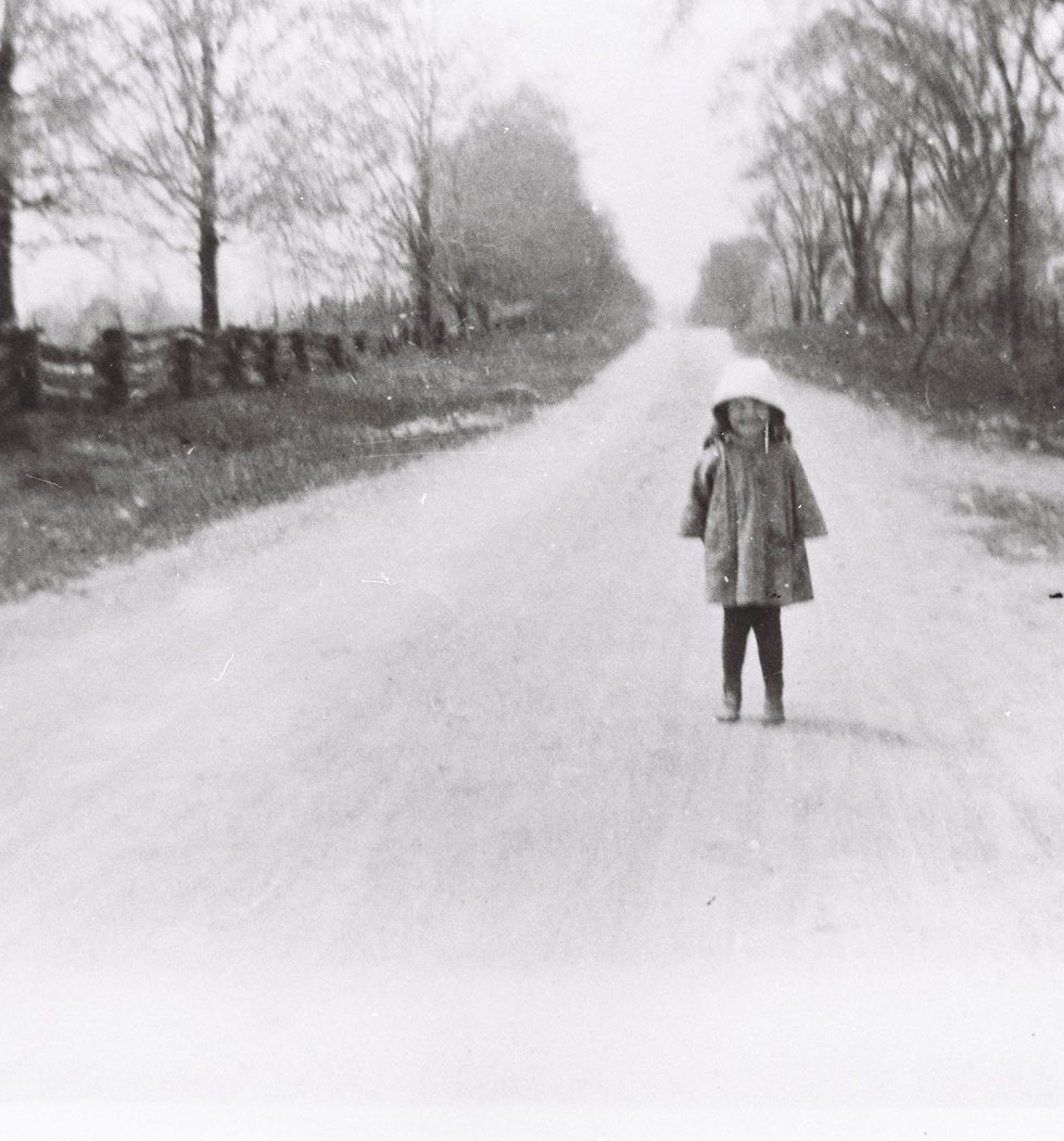
Over the past few months Roger has been kind enough to share some photos from his family’s collection. Many of the colour photos were taken by Roger himself when he was a young man in the 1960s. Most of them show scenes from along Hazeldean Road and Young Road. He’s been collecting and organizing them as part of a family history project.
The 1960s photos were taken just before the area started its transformation into a suburban community, with the development of Glen Cairn and later Katimavik. They provide a fascinating view into into the history of our community.
I’d like to thank Roger for his generous hospitality, and the time he’s spent to meet with me and share his photos and fond memories of the old village.
(Click on any photo to view larger size.)

Photo from the collection of Roger Young.


Photo from the collection of Roger Young.


Photo from the collection of Roger Young.

Photo from the collection of Roger Young.

Photo from the collection of Roger Young.

Photo from the collection of Roger Young.

Photo from the collection of Roger Young.


Photo from the collection of Roger Young.


I moved to what was Hazeldean in 1958 to property at the corner of what is now Maple Grove and McCurdy Drive. Our house is still there. I went to school with Roger Young in the one room school SS#13 in the same grade from grade 3 through grade 8. My Dad, Ron Watts would help Gordon Young, Rogers father, at Youngs store sometimes on weekends. We lived across of what was the location of the cheese factory. All that was left when we moved there was a portion of an old well. On our property there were the ruins of an old stone house which we took down as it was unsafe, but not before we had great climbing times when my brothers and I were young. We saw Hazeldean and Kanata grow up around us.
I suppose that you lived in the corner house (33 Maple Grove), replaced in 2022 by two oversized walk-up apartment buildings after a lot of controversy over the City’s VERY permissive zoning treatment.
This is the first I’ve heard of a cheese factory in our neighbourhood. Was it on the lot on the other side of Goulbourn Forced Road–cum–McCurdy Drive, where the Presbyterian church (now the Ruddy-Shenkman Hospice) was built, or on the north side of Maple Grove?
Stunning photography; well done Roger! Seeing your pics of the lost village of Hazeldean brought back a flood of memories. I can still imagine the green grocer smell that greeted visitors who walked into your family store. Oddly, I can also hear the hum of the power lines in the absolute quiet of a crisp country night as I walked north on Young’s Road past your grandmother’s house, old St. Pauls and onto the Douglas farm were Costco and the hotel now stands at Terry Fox and Katimavik. While I’ve lived in several places and was actually born in SW Ontario, when the conversation turns to “and where are you from”, my answer has never changed and still is “Hazeldean”.
Blake Eric’s brother?
The barn pictured belonged to Albert Bradley, blacksmith and carriage maker. It was located on the corner of Hazeldean Road and Young Road. The original store (the left part) was built in the 1850s for Adam Abbott. The house attached (the right section) was built by the Cummings family, who owned the store in the 1890s. It was originally right beside the road, but was moved back in the late 1950s. It is niw the location of the mall with Henry’s camera store.
Roger I think I have known your grandparents Frank and Willow Young back in the day when I was growing up. Was out many a time to the house on Youngs Road your Aunt Merial used to cut my hair when I moved out to Stittsville.
I know Maple Grove well the cematary where Frank and Willow are buried as well as Lela and Harold Doyle, which is how I met them in my early years. It was back in the day once you left Bells Corners you would drive over the train tracks and be in darkness the rest of the way no lights, and a dirt road if I remember.
At one time was going to put an offer in on the house back in the 80’s when just married. lots of memories.
Hi Colleen-thanks for your note. You are correct about everything. As a child I remember when Bell’s Corners was just a hamlet and the long drive from there to Hazeldean. I remember the road as paved, but it seemed to take forever to get to Eagleson’s Corners. How do you know the Doyle’s? Best wishes.
Did this bring back memories and actually gave me goosebumps remembering the good times back then. My Mom and Dad always filled up at Young’s and spent more time visiting with Gordon and Audrey than pumping gas. Family was always the talk (Audrey is my Grandfather’s sister’s (Innie) daughter) and any current events took up time as well. Gordon would always slip me a candy or two on every visit. I remember so well biking those old dirt roads with our group of Stittsvilleite kids and the openness of the area with not a care in the world. It was like living in paradise those days, but little did we know what the future would bring. Roger, thanks so much for sharing your photos with Stittsville Central and bringing my fond memories to life again! Glen, thank you so much for bringing us the history of what once was.
Thank you so much for sharing these pictures…the history is so interesting and makes me appreciate my Stittsville home.
Good article!
Lovely piece and fantastic photos. Thanks for sharing!
Roger Young and Stittsville Central – thank-you so much for sharing these wonderful pictures and memories! My husband and I were married in St. Paul’s Anglican Church on Young’s Road many years ago. All of our out-of-town relatives who come to visit us now, don’t recognize Hazeldean because of how it’s grown. We were so privileged to have experienced and lived those amazing early times, that are now gone forever. Thank-you so much!!!
I grew up in Richmond and am familiar with Hazeldean area. I have been in BC since 1991 and similarly see farmlands being converted into townhome developments and wonder when it will turn from what you shared to what is now. Thank you for sharing.
I am new to stittsville however it was wonderful seeing these photos.
Thank you for sharing.
My parents moved us to Hazledean in the early 1950s. They had married in Haliburton. My Dad was an Ottawa boy. They lived somewhere in Hazledean and my older siblings went to the old school house, but it didn’t look like the one in the picture Roger Young has. It was smaller and maybe stone? I was too young but I d9nhave a picture somewhere I will try to find and post.
I truly love the Kanata/Stittsville area!
The school you are thinking of was built in 1911 after the one in the picture burned down in 1910. I went to that school as well. My teachers were Mrs. Flossie Moffatt, Mrs. Mary Davidson, and Mrs Gwen Eglington. 1956-1964.
Mrs Mary Davidson tutored me in math in the 1960s. I have fond memories of going to her house in Stittsville for my lessons after school. I would take the bus from Goulbourn Township Public School to Stittsville. Mr. Johnny Davidson would sit in the front room while we grappled with math at the kitchen table. She was a dedicated teacher and a lovely human being.
hi Roger – could you tell me please if there was a school where the Macs milk and Hong Chow restaurant used to be and if there are any pictures of it – I was told it was the Hazeldean school thank you for any help
I too moved to Hazeldean back in 54. We lived on the Hall farm on the way into Stittsville, went to the one room school with Mrs Alexander as our teacher. The McClellands’, Cole, Sparks, and I’m pretty sure the Fox’ had the store across from the school. Some of the boys from Stittsville, I think the last (or first) name of one of them was Halsey.
I’m almost 80 now living in BC since 73, but those fun memories have lasted since.
Kathleen McCarthy (Leighton)
My parents rented the Grant farm in the summertime for our cattle and my mother would organize excursions to berry pick at the Grant place, where there were huge raspberry bushes. I have fond memories of that time. The Grant barn was still standing. We were told the story of how Mr. Grant died in the 1870 fire on the same property when he went back into the burning house to collect some important papers. Lots of history in this area. Thanks for posting these pictures.
The Grant farm was my family’s farm. (Yes, my Great-great grandfather, Robert Grant, was killed in the 1870 Fire.) We used to go out from the west end of Ottawa on weekends to visit my uncle, Arthur Grant, when I was a kid in the 50s & 60s. He was the last of the family in the house. I remember Hazeldean looking like this. I can’t fathom how much its changed now. So nostalgic seeing these images.
Extremely interesting! It is a reminder that some of the small things we do when we are younger (such as taking some time to record neighbourhood pictures) end up being priceless in the future. Am surprised to see just how much the neighbourhood has been built up in such a short time – the reality is quite different from the assumption that “development” was a gradual evolution over the past 200 years.
Speaking of 200 years, 2018 is (apparently) the 200th anniversary of the founding of Hazeldean (according to the City road signs on Eagleson and other major nearby roads greeting travellers). The Katimavik-Hazeldean Community Association (incorporated and active since 1980), will be commemorating this occasion on July 1 / Canada Day in Kanata as part of the celebrations at the Kanata Recreation Centre toboggan hill. We will be serving cake, and all those Katimavik-Hazeldean residents signing up as members of our Association will be given a special 200th anniversary lapel pin recognizing the 200th anniversary of the founding of the Hazeldean settlement (membership is $10 a year per household). A bit more info, and a picture of one of the road signs, can be found at http://www.khca.on.ca
Thank you very much for your work, Glen… and thank you to Marc Labreche who brought this to my attention. Perhaps there is a way we can publically display some of these pictures at the Canada Day celebrations?
Thank you so much for the photos and accompanying historical comments about Hazeldean’s past.
I was born and raised on Fernbank Road (lot 29 Concession 10 Goulbourn Township), and often travelled with my parents, to and through Hazeldean via the Hazeldean Side Road, Young Road etc. We would be going to visit my Grandmpther at my Mother’s birth place on the Goulbourn Forced Road, now called Terry Fox Drive.
Very much enjoyed this. We lived at the Harton House Farm from 1950 to 1957 and I attended SS#13 Goulbourn during that period of time. We were burned out in 1953, but stayed on until 1957 when we moved back to Westboro. My Grandmother was a Grierson of the Torbolton and Alf and his family are cousins. No visit to Ottawa is complete without visiting Hazeldean and its little cemetery to visit Muriel and the Young’s plot. I rode my pony all over the backroads in the area. We used to drive Chuck Wall crazy as his granary was right next door to the school and we would smoke in the loft. Many strappings from Flossy Moffat for those capers. Alf had a large bull that he kept in the field behind the school. He had to move it as the fence was all wowed when we used to tease the bull and he would charge the fence. Christmas concerts were held in the hall across from Young’s store. This brought back many fond memories.
Tim Cole Burnaby, B.C.
Tim – thank you so much for your memories. I, too, remember that of which you spoke. My grandfather built the Grierson barn (Orville Parks) along with other barns here in the ‘former’ Goulbourn Township. Flossy Moffatt was quick to draw out her strap. I never experienced it, but heard about it. Gordon Young and Audrey (nee Davidson) are my cousins through Audrey’s side of the family (Parks) of Fallowfield. Roger Young, Gordon and Audrey’s son, just recently presented the history of Hazeldean to our local historical society. Lots of family members and former residents were present. Brought back many fond memories for me. Thanks again. Lesley
Hello Lesley:
Thanks for the kind words. Muriel Bradley was like a surrogate mother to me and we were very close. My wife is a Vancouver girl and it means so much to me to be able to show her photos of where I grew up. As a child I played in some of the barns shown in the photos. Particularly the Sparks barn next to Alf Griersons. I am in the process of writing a book mostly describing 55 years in the aviation industry, however there is a personal chapter that describes my life as a child in the Hazeldean and Stittsville area. I am targeting the end of 2019 or early 2020 to publish. Once again these photos bring back so many memories. Ida Alexander was my other teacher at SS#13 Goulburn. She too could wield a mean strap. At one time I claimed to have had more strappings than any other kids at the school. It was kind of a badge of honour. I guess I must have been a real challenge…….can you imagine this happening in today’s society? Frank Young was the caretaker of the school. He would be there every morning and see that the school was warm. Unlike many of the other schools in the area in the 1950s (the 10th line etc.) our school had an oil furnace. It also had two chemical indoor toilets. There was no running water but there was a pump on the east side of the school. I remember carrying buckets of water from the pump to build a skating rink. I wonder if anyone remembers Arbour Day? It was traditional to plant a tree on the front of the school grounds on Arbour Day. Thanks again. Tim Cole, Burnaby, BC
I remember all the things you mention, although you were at S.S. # 13 before me. You have described the school perfectly. It’s nice to hear your memories, including those about me grandfather, Frank Young. Muriel is my aunt (my father’s sister.) I leave today very near where you did. I got the strap once or twice from Mary Davidson, but not from Flossie. They both taught in the school after they divided it by building a wall in the middle. The most common punishment was the writing of “lines” after school. I think they put in plumbing after a fire inside the school about 1962.
Hi Tim … I guess you remember Kathleen & John Leighton from SS#13 in the 50’s? Your family had the farm right beside us … John Hall’s farm. My Dad & Mr. Robinson worked for Mr. Hall. It was great to see your name and read your recollections of that time. I remember when they tore the schoolhouse down and many people went out to gather bricks and other bits & pieces) as mementos. LOL
Hello Tim – would u be able to tell me ab0ut the Grierson Family? Our family emigrated from the Netherlands in 1953 . We spent one week in a house, think it was on Hazeldean, and my Dad worked for farmer Grierson for a week or so. Any relation to you??
Have some pretty neat pictures for you, if this is family.
Thank you for taking the time to read this.
Jane Vandesande
Thank you for the pictures Roger Young – was there a school house on Hazeldean road – I was told it was a 2 storey red brick building and would you have a picture of it .
I live in Hazeldean in 1966, I had one child. I lived up young rd, to a left turn. I forget the
Name of the road(or if it was still Young rd). We rented a lower duplex from the Wynche’s, or
Winch, I forget! The highlight of many a day, was walking down to Young’s Store!!, for some
Contact with friendly people….. I had no car in those days! Thanks for all the interesting photos!
Apparently a relation of my grandmother’s, a Mr. Wallace Lang, owned a general store in Hazeldean sometime in the 1940s. I wonder if it was from him that Mr. Young’s father purchased the Groceteria.
No, the Hill family owned it after Wallace Lang.
Love the old photo’s. My family the Bradley’s were from Hazeldean-stittsville area. Jacob Bradley was my 3x great grandfather. Would love to learn more about this area.
Carrie Reddick:
I too am a descendant of Jacob Bradley. Love to hear from you. I’m on Facebook.
Don Condie
Does anyone remember the McFaddens of Ashton. They came to Canada in 1828 and my grandfather James married a Tamen and I cannot find Tamens anywhere.
Hi Judy – we do remember the McFadden family of the Ashton area. With regards to your search for the Tamen family, you have spelled the name incorrectly – it is Taman with an ‘a’ not an ‘e’. Below is some family tree information of the Taman family that we hope will assist you in your search. There is quite a large presence of the McFadden family history on various genealogy sites.
Joseph Taman
Born 1 Jan 1833 in Goulbourn Township, Upper Canada, British Colonial America
ANCESTORS
Son of Joseph Taman and Mary Jane (Hare) Taman
Brother of John Taman, Henry Taman, Elizabeth (Taman) Purdy, Robert Taman, William Taman, Jane Taman, Hannah (Taman) Moore, Margaret (Taman) Featherston and Rebecca May (Taman) Daly
Husband of Eliza (Greer) Taman — married 7 Jan 1867 in Leeds and Grenville County, Canada West, British Colonial America
DESCENDANTS
Father of Mary (Taman) Irwin, Joseph Elijah Taman, Eliza Anne (Taman) James, Margaret Lucinda (Taman) Cox, Addie May (Taman) Vincent, John F. Taman and Samuel Wesley Taman
Died 5 Feb 1912 at age 79 in Blyth, Ontario, Canada
Was there a school house approximately where the Macs Milk store used to be and Hong Chows and if so could there be a picture of it — thank you for any help
I’m here because I inherited a watercolor painting from my mom recently, all the way across the Atlantic in Germany.
It depicts an old stone building and is inscribed with “Hazeldean Ridge Farm Kanata -R. Randell, 1985”.
When I found the place on Google maps it was just a suburban landscape like all the rest – safe to say it changed a lot.
Couldn’t see that specific building in any of the pictures here, unfortunately. I guess R. Randell must have been a local painter.
Thanks for this view into the past.
Hello, sorry for commenting on an older blog post, but I’m having trouble finding out who Hazeldean actually was that stuff was named after them. Can anyone point me in a good direction or have information? Thank you!