


The City of Ottawa is holding an open house on Thursday, December 7 as part of the Environmental Assessment for the light rail extension to Kanata-Stittsville.
There’s a significant change in plans from the last open house held in June: An updated map of the potential LRT extension to Stittsville shows the end of the line at Hazeldean Road, instead of Canadian Tire Centre.
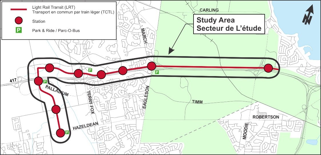
This route runs parallel to the Queensway from Moodie Drive, swinging north towards Campeau before heading south. The original route plan would have ended at Palladium, but a new map shows additional stops at Maple Grove and Hazeldean Road.
The rail line would run just east of the Fairwinds neighbourhood and Toys R Us on Hazeldean Road. The map shows a park-and-ride at Hazeldean Road.
This is all still many years away. Phase 2 of light rail to Moodie Drive is scheduled to be completed by 2023, so this project would come sometime after that — probably somewhere between 2023-2031. It also needs funding approval. (I have a feeling there will be a lot of pressure on the City to accelerate the timeline, once people realize next year how many transfers they’ll have to make to get from Stittsville to dowtown.)
Despite the change in terminus, for some reason City staff and councillors keep referring to this as the LRT extension to Kanata — rather than Stittsville!
The meeting on December 7 happens at the Kanata Recreation Complex, Hall A (100 Charlie Rogers Place) from 5:30pm to 8:30 p.m., with a presentation at 6:30 p.m. The location is served by OC Transpo routes 61, 88, 167 and parking is available.
Here’s the official text from the City of Ottawa about the meeting:
The City of Ottawa has initiated this Planning and Environmental Assessment (EA) study to develop a Recommended Plan to extend Light Rail Transit (LRT) from Moodie Drive to Kanata. Extending LRT to Kanata is identified in the Ultimate Network in the City’s 2013 Transportation Master Plan (TMP). The previous Open House for this project was held in June 2017. At that time, the City presented the evaluation of alternative corridors and identified a preliminary preferred corridor.
To date, the Study Team has finalized the recommended corridor and at this open house will present design details on the recommended plan, station locations and concept designs, and the requirement for a light maintenance and storage facility.
The Environmental Assessment portion of the study will be undertaken in accordance with the Transit Project Assessment Process (TPAP) as prescribed in Ontario Regulation 231/08, Transit Projects. The City must consider alternative corridors and designs for the project, undertake public and agency consultation, assess the potential environmental effects of the Recommended Plan and identify measures to mitigate any such impacts.
Comments received will be collected under TPAP, and with the exception of personal information, will become part of the public record.
Accessibility is an important consideration for the City of Ottawa. If you require special accommodation, please contact the project manager below before the event.
For further information or to provide comments, please contact:
Angela Taylor, P.Eng.
Senior Project Engineer
Transportation Planning – Transportation Services Department
City of Ottawa
Email: Angela.Taylor@ottawa.ca (link sends e-mail)
613-580-2424 x 15210
Ending routes at special use facilities like Palladium means regular users are dropped quite far from residences or shops. This implies walking distances across exposed areas (cold/wind). Ending somewhere with shops, cafe’s, and shelter increases security and likely (I don’t have studies unfortunately) increases ridership. So moving the terminus to Hazeldean is sensible.